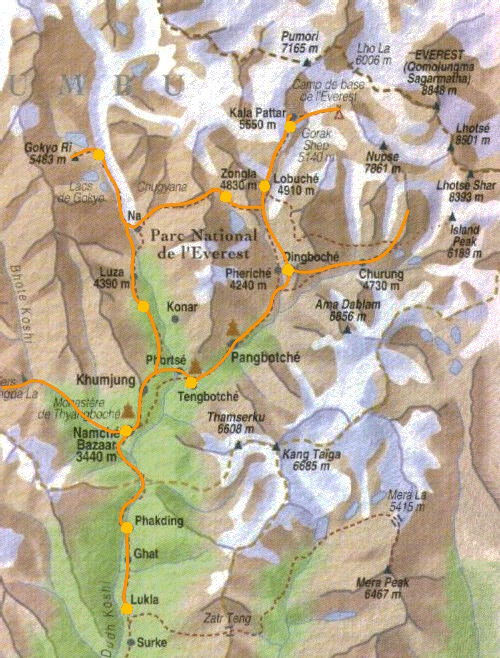
L’itinéraire
De Katmandou (1300 m), j’ai rejoins Lukla (2840 m) par avion. De là, je suis parti à pieds jusqu’à Namche Bazar (3440 m) où je restais 2 nuits pour m’acclimater à l’altitude. Puis jusqu’à Dingpoche (4410 m) où j’ai fait une nouvelle acclimatation. Puis après être monté en haut du Kala Patar (5550 m), je suis installé à Gorak Shep (5125 m) d’où je ai rejoins le Camp de Base (5380 m) après 9 jours de marche.
Après cette première étape, je me suis dirigé vers les lacs de Gokyo (4790 m) et le pic de Gokyo (5360 m) en passant par le col Cho La (5330 m). Après 15 jours de marche, je suis retrouné Lukla pour prendre mon avion de retour.
| Date | Étape | Altitude |
| 1 | Lukla | 2840 |
| Ghat | 2492 | |
| Phakding | 2610 | |
| 2 | Bengkar | 2905 |
| Monjo | 2840 | |
| Jorsale | 2805 | |
| Namche Bazar | 3440 | |
| 3 | Phurte | 3390 |
| Thomde | 3493 | |
| Samde | 3640 | |
| Thame | 3840 | |
| Samde | 3640 | |
| Thomde | 3493 | |
| Phurte | 3390 | |
| Namche Bazar | 3440 | |
| 4 | Sangboche | 3720 |
| Kumjung | 3780 | |
| Sanasa | 3600 | |
| Phunki | 3250 | |
| Tengboche | 3860 | |
| 5 | Deboche | 3820 |
| Pangboche | 3930 | |
| Dingboche | 4410 | |
| 6 | Chhukhung | 4730 |
| Pic Chhukhung | 5550 | |
| Chhukhung | 4730 | |
| Dingboche | 4410 | |
| 7 | Duglha | 4620 |
| Lobuche | 4910 | |
| 8 | Gorak Shep | 5140 |
| 9 | Kala Patthar | 5550 |
| Gorak Shep | 5140 | |
| Camp de Base de l’Everest | 5380 | |
| Gorak Shep | 5140 | |
| 10 | Lobuche | 4910 |
| Dzonglha | 4840 | |
| 11 | Col Cho La | 5330 |
| Dragnag | 4700 | |
| Gokyo | 4790 | |
| 12 | Pic Gokyo | 5360 |
| Gokyo | 4790 | |
| 13 | Pangka | 4550 |
| Machhermo | 4470 | |
| Luza | 4390 | |
| Dole | 4110 | |
| 14 | Phorste Tenga | 3680 |
| Mong | 3973 | |
| Khumjung | 3780 | |
| Khunde | 3840 | |
| Sangboche | 3720 | |
| Namche Bazar | 3440 | |
| 15 | Jorsale | 2805 |
| Monjo | 2800 | |
| Bengar | 2840 | |
| Phakding | 2610 | |
| Ghat | 2492 | |
| Lukla | 2840 |
A télécharger mon topo